Q:
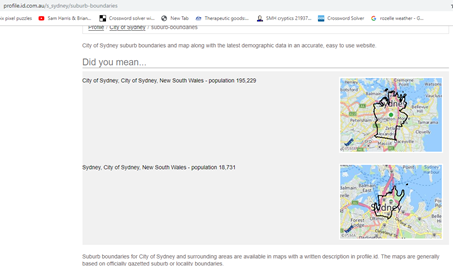
Why have you got two different maps for the City of Sydney?
Only one can be right!
A:
Hi, thanks for your query.
The two maps relate to different areas.
The first is the legal Local Government boundary of the City of Sydney, which incorporates a number of suburbs and precincts.
The second is the locality or suburb of “Sydney” within the City of Sydney, which is the central area which can use the address “Sydney”, rather than other suburbs in the municipality (eg. Chippendale, Zetland, Rosebery, Potts Point etc.).
I hope this clears it up!
Regards,
Glenn
Learn more
There is more information on this page about why the data, modules, maps and boundaries on one of our local area profiles may be different to what is on another profile or another product or resource for the same area.